-Yanahuara Lookout
2 km / 1 mile from downtown Arequipa (8 minutes by car)
It was built in the nineteenth century and is composed of a series of sillar stone arches where the words of famous Arequipa citizens have been engraved. This spot is a wonderful view point of the city and MountMisti volcano.
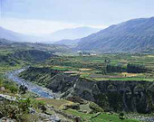
-Sabandia
8 km / 5 miles from Arequipa (20 minutes by car)
Wide terraces and three volcanoes, the Misti, the Chachani, and the Pichu Pichu, provide the scenery around this traditional town. Some of the houses still preserve characteristic styles of the Viceroyalty or of the nineteenth century Republicanism. A recreational area with two swimming pools that use the cold river waters of the surrounding region has been built.
-Molino de Sabandía (Sabandía Mill)
Located in Sabandía
Constructed in 1785, it represents the typical architecture of the zone where the use of sillar stone predominates. It is characterized by solid supports and rustic balconies. Stone grinding wheel techniques for wheat processing can be viewed here as well.
-Mansión del Fundador (Founder's Mansion)
9 km / 6 miles from Arequipa (15 minutes by car)
Built with sillar stone at the edge of a cliff, it is one of the most important and traditional mansions or houses in the department. According to the story, Garcí Manuel de Carbajal, founder of Arequipa , had it built for his son. Later, in 1785, Mr. Juan Crisóstomo de Goyeneche y Aguerreverre was its proprietor and remodeled it, giving it the distinguished characteristics that can be seen today. The main entrance is composed of a foyer with an arched ceiling, followed by a wide principal patio over which the windows and doors of the bedrooms open.
-Urbanización Selva Alegre (Selva Alegre suburb)
Considered the “garden of the city” for its large parks and huge trees that live in harmony with the modern houses of the area, Selva Alegre was constructed as a monument to Juan Pablo Vizcardo y Guzmán, fore runner of the Peruvian independence. The Molino de Santa Catalina (Mill of Saint Kathleen) is anothersite to visit, completely restored and located on the mall of this zone.
-District of Cayma
3 km / 2 miles south of Arequipa (8 minutes by car)
The village of Cayma is known as the “Balcony of Arequipa” for its advantageous location that allows the entire city to be seen. Its central plaza houses the church of San Miguel Arcángel (Saint Michael the Archangel ), built in 1730 and considered an architectural jewel because of its mixed façade. In the rectory annex, the “Comedor de Bolívar” (Bolivar's dining room) is preserved where, according to legend, the Liberators used to have lunch during their stay in the town.
-Misti Volcano
The foothills of the volcano are located 20 km / 12 miles. northeast of Arequipa (1 hour by 4x4 vehicle)
The Misti volcano, 5825 masl / 19.111 fasl is the guardian of the city. From the summit, you can see the city of Arequipa , the ChiliRiver valley, and the Chachani and Pichu Pichu volcanoes.
-Yura Hot Springs
27 km / 17 miles north of Arequipa (45 minutes by bus)
These are wells of thermal waters at the foothills of the Chachani volcano, 2575 masl / 8448 fasl. The therapeutic properties of the waters, which temperature fluctuates between 23ºC (73.40ºF) and 28ºC (82.40ºF), are celebrated. Between 1810 and 1831, Mr. José Nogal y Noguerol built the wells that are still maintained today.
-Sumbay Caves – Rock Art
97 km / 60 miles north of Arequipa on the Caylloma highway (1 hour and 45 minutes by bus)
Located within the boundaries of the Salinas and Aguada Blanca National Reserve, this area boasts over 500 rock art figures. These representations, possibly made by the first inhabitants of the area, are approximately 6000 to 8000 years old.
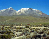
-MountChachani
The base camp is 55 km / 34 miles north of Arequipa (2 hours by 4x4 vehicle). From there, an approximate 6-hour hike will take you to the summit.
This snow covered peak, towering over 6075 masl / 19931 fasl is considered one of the most difficult mountains to climb in Peru . It is an inactive volcano, but lava is still visible, and there are depressions and moraines. It takes two days and one night to ascend.
-District of Yarabamba
21 km / 13 miles south of the city of Arequipa (35 minutes by car)
The name of the district comes from two Quechua words: “yaro” or “yara”, a native bush of the area, and “bamba” which means pampas. Visiting the mansion of Arenas y Pinto and the colonial house of Rivera y Echevarría are the things to do in the town.
-District of Quequeña
25 km / 16 miles southeast of Arequipa (40 minutes by car)
This area has been inhabited by the Lupacas, Aymaras, Quechuas, Collaguas, Puquinas, and, in the middle of the fifteenth century, the Incas. The name of the town probably comes from the Puquina word, “quequeña”, which means “rocky and solid place”. The main places of interest are la Alameda de los Sauces (Willows Walk), la Alameda de los Muertos (Path of the Dead), and Guanaqueros Gorge. There is also a recently restored church to see.
-District of Chiguata
30 km / 19 miles east of Arequipa (45 minutes by car) at the foothills of the Pichu-Pichu volcano
Chiguata was founded on January 22, 1540, by the steward - Diego Hernández. The name of the city is a combination of two Quechua words, “chiri” (cold) and “guata” (year), and means “cold all year long”. Among the main attractions, you can visit the Iglesia del Espíritu Santo (Church of the Holy Spirit) and the archeological centers of Tambo de León and Infiernillos.
-District of Tiabaya
10 km / 6 miles from Arequipa (15 minutes by car)
The valley is completely agricultural and is believed to have been inhabited by the ethnic groups of the Kuntis from Cabana, the Yanahuaras, and the Chumbivilcas. On November 8, 1870 , it was given the title of “city” and is famous for its rustic restaurants.
-District of Characato
10 km / 6 miles from Arequipa (15 minutes by car)
This town has plenty of vegetation and abundant water, so it is ideal for farming. Very close to the town is the “Ojo de Milagro” waterspring (Eye of Miracle Spring). There is also a beautiful colonial church. Historically, the inhabitants of this area went to work at the southern salt licks, now territory of Chile . When the people of this place were asked where they were from, they used to say “from Characato, sir”; that is where the nickname of the people of Arequipa – “characatos” come from.
-Salinas and Aguada Blanca National Reserve
35 km / 22 miles northeast of Arequipa (1 hour and 30 minutes by bus)
The reserve covers almost 367.000 hectares, including territory from the Provinces of Arequipa, Caylloma (department of Arequipa), and General Sánchez Cerro (department of Moqueqa). It was created for the purpose of preserving important associations of flora and fauna, protecting the natural environment that was deteriorating and in the process of being destroyed, as well as caring for the vicuña through a repopulation program. The reserve is located between 2800 and 6050 masl (9186 and 19.849 fasl) and the Misti (5825 masl / 19.111 fasl), the Chachani (6075 masl / 19.931 fasl), and the Pichu-Pichu (5664 masl / 18.583fasl) volcanoes are found there.
Among the most representative species of the reserve are the vizcacha, the fox, the condor, and the Andean flamingo or parihuana. Scientists have determined the existence of 169 animal species, 23 of which are mammals (including two forms of domesticated South American camelids), 138 species of birds (blue billed ducks, eagles, and kestrels are the trophies), 3 reptilians, 4 amphibious, and 3 fish species. SalinasLake is considered a special spot to observe flamingos during their migration period.